| Attachments: |
|
path.jpg [ 101.7 KiB | Viewed 5867 times ] |
| Lamma Forums http://lamma.com.hk/forum-OK/ |
|
| Pak Kok To Suk Kwu Wan? http://lamma.com.hk/forum-OK/viewtopic.php?f=24&t=11859 |
Page 1 of 1 |
| Author: | charlie [ Tue Aug 28, 2012 7:34 pm ] |
| Post subject: | Pak Kok To Suk Kwu Wan? |
Is there any path from Pak Kok to Suk Kwu Wan without going through Yung Shue Wan? |
|
| Author: | Alan [ Tue Aug 28, 2012 9:29 pm ] |
| Post subject: | Re: Pak Kok To Suk Kwu Wan? |
Go to Pak Kok Kau Tsuen then uphill to Tai Peng. Go through to the other side to the cable road. Then to Lamma Winds, you can shortcut on a dirt track over the hills -- you can see the turbine so you won't get lost. Or follow the cable road and divert to the second cable road where they meet, go left uphill to Lamma Winds. Then opposite Lamma Winds is a footpath along the hills to the Youth Hostel. Take a left there along the concrete path and you'll come around a hill and join the "Family Trail" to SKW. |
|
| Author: | charlie [ Thu Aug 30, 2012 8:16 pm ] |
| Post subject: | |
Thanks Alan. I asked this question because one of my friends invited me for a hike from Pak Kok to Suk Kwu Wan. I thought he was joking but it turns out that there is really a path. I walked that dirt path once several weeks ago. Is the footpath along the hills to the Youth Hostel beside the pavilion? |
|
| Author: | Alan [ Thu Aug 30, 2012 10:46 pm ] | ||
| Post subject: | |||
|
|||
| Author: | Lamma-Gung [ Fri Aug 31, 2012 12:13 am ] |
| Post subject: | |
Charlie meant the pavilion above Lamma Winds, I think. No need to go up there to get to Sok Kwu Wan, but you could indeed go past the pavilion along and over the small hills behind it and join the Snake Trail to the Youth Hostel after a few hundred metres, but I wouldn't recommend it, too overgrown during this time of year. You might get too close to a snake or critter hiding in the underbrush you can't see. Wear good, closed hiking shoes and long trousers to avoid bites and scratches while hiking on dirt paths. The short-cut from the Cable Road over Mt. Panorama to Lamma Winds is fun, but only when it's dry and not too slippery. You could get to Lamma Winds completely off Cable Road, following the mountainbikers' dirt paths, much more scenic and interesting than the Cable Roads. The entrance to the Snake Trail from Lamma Winds starts a few metres to the right of the bottom of the stairs going up to the Pavilion above Lamma Winds. Don't take the stairs, walk 10 metres to the right on the street and then into the bushes, you can't miss it. Have fun and don't ride the bike on the Snake Trail, all along steep hill ridges, except you're an experienced mountainbiker. I did that only once.... Do it before the Govt. decides to concrete the entire Snake Trail in a few years, perhaps. They've already put in concrete stairs from Lo Tik Wan all the way up to the middle of the dirt path-only Snake Trail. A few photos from one of my recent Snake trail hikes, including a GPS-recorded map of my hike, taking the steep short-cut over Mt. Panorama: http://www.compunicate.com/Lamma-zine/Blog/Blog-2012-04.html#Apr4 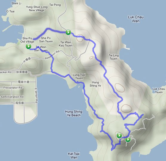
|
|
| Author: | alessandro65 [ Thu Jan 03, 2013 10:36 pm ] |
| Post subject: | |
| Page 1 of 1 | All times are UTC + 8 hours |
| Powered by phpBB® Forum Software © phpBB Group http://www.phpbb.com/ |
|